Know Thy Deserts- A Journey Through Americas Great Deserts

The Organ Pipe Cactus are a strange tentacle like cactus that grow nearly 20 feet tall and seem to like hugging close to the cliffs around the southern half of the monument in which they live. These cactus are only found within a small region of the Sonoran Desert near the gulf of California, away from the potential of frost. On this morning we had soft distant clouds resulting in a pastel sunset.
I have completed a life goal I never knew I had until it was presented to me. I finally visited all of North Americas great deserts. Yes there are four deserts in North America, but lets include the Colorado Plateau because I am biased towards it, and that makes five for this article. These deserts can be technically subdivided into a few others ecoregions (smaller deserts) and there are a few more areas that qualify as deserts (they don't get included in this list for other reasons), but for practical purposes lets just focus on these five.
Now you might wonder what are these five deserts? Well let me tell you!
The five North American deserts are the Colorado Plateau, Great Basin, Mojave, Sonoran, and the Chihuahuan deserts (Figure 1). The Colorado Plateau desert includes Utah, Arizona Colorado and New Mexico. The Great Basin spans from California, most of Nevada and the western half of Utah. the Mojave encompasses parts of California, Nevada, Arizona and a smidge of Utah. The Sonoran Desert resides within California, Arizona and drops into Mexico. Finally the Chihuahuan desert resides within New Mexico, Texas and Mexico.
Now you know, so lets get to the fun stuff of photography.
Up until this point in my life I have photographed within the Great Basin, Mojave and the Colorado Plateau deserts with one image from the Sonoran Desert. And frankly I was generally content with that. I had a myriad of stuff to explore throughout these deserts but when opportunity arises for something more, take it!
Late in 2022 a photographer, Nic Stover, in California reached out to me about his plans for his spring desert trip. In previous years we had been to the Paria River and to the Maze District of Canyonlands. So when he mentioned his next planned spring trip, I figured it would be someplace in Utah. But when I got the itinerary it was not my home state, but of California, Arizona, and New Mexico. After glancing over the plans, I realized I could not make it to all of the locations, but I could make the Arizona locations and possibly New Mexico.
I generally didn't think much of the trip since the initial invite, but a few weeks before we left I began to read up on where we were going. It was at this moment I realized I was going to do a grand tour of the eco-regions of the American southwest. As an ecologist, this was an opportunity to do an eco-photographic journey across the region and create a portfolio of all the deserts of North America. I had only really passed through the Sonoran Desert a few times as an adult and only once as a photographer and I had never been to the Chihuahuan desert.
New life goal!

I have learned through the years that this little arch on the outskirts of St. George lines up quite nicely with rainbows when they drop near the Pine Valley Mountains. On this evening when conditions were combining I knew I was probably going to get some magic. Low and behold the rainbow dropped across the skyline and the clouds lit up.
So lets begin the grand tour of the American southwest with my home deserts, the great basin, Mojave and the Colorado Plateau. From where I sit I look north to the Great Basin, east to the Colorado Plateau and west to the Mojave. In order to do this properly lets begin this tour in about the same direction as I did this photo trip. I currently reside in St. George, Utah, right on the border of all of them, so a mixture of all three. Since I left and directly cut down into the Mojave, lets begin with the Great Basin, so that it is not missed.
The Great Basin

In 2021 there were fires all across the western united states. I was on my way home from a job interview and decided to stop by Cedar Breaks National Monument. I ended up catching a few nice sunsets, but the end of the evening brought about some dramatic skies. The clouds settled in the distance but the heavy smoke stained the sky red creating a surreal crimson layer of peaks extending into the distance.
The Great Basin is typically comprised of a series of mountains and valleys that run north and south all across the western half of Utah, all of Nevada and into California. Technically this geological topographical feature actually unites all the deserts of the American southwest, except the Colorado plateau. All of which is called the basin and range province of North America (read more here). Within the Great Basin though, all the water that falls within never leaves, leaving much of the landscape salty and covered with either sage brush or salt brush.
Photographically though, there are many interesting things scattered across the great basin. Frankly the basin and range topography makes for unbelievable photographic conditions (see above image). Trapped within this desert are geological wonders like the Salt Flats of northern Utah, the sand dunes of the west deserts of Utah, and one feature that is generally overlook by the photographic community, the springs of the desert.

I did not come here to do landscape photography, but when the occasion arises you do landscape photography.
One interesting feature of the basin and range is the propensity of springs that come boiling out the ground near the base of mountains throughout the Great Basin desert. These springs are oasis and provide critical migratory habitat of birds, and homes to a small collection of isolated endemic fish trapped since the end of the Pleistocene when this land was once covered in giant freshwater lakes filled by melting ice sheets.

The Salt Flats are kind of an other worldly location. When water is thrown into the mix, the exerpience gets even more wild. Due to the salt adding density to the water, the water becomes stable and very smooth resulting in almost perfect reflections upon the waters surface.
As mentioned though my journey from St. George quickly descends into the Mojave desert. Thats where we will go next.
The Mojave Desert

Having a super bloom of flowers to photograph is a magical moment. Having it happen in Joshua Tree National Park is a great magical moment. I was lucky enough to catch such an event as the full moon rose over a desert covered in small yellow flowers.
The Mojave desert located through southern Nevada, California, Arizona and a smidge in my home state, Utah. Generally people think California when they think Mojave, but in all reality all of these states can claim some aspect of the desert as their own. All of these states have a preserve or two focusing on protecting pieces of this desert. But only one has set aside huge swaths of land as national parks to preserve aspects of this desert and that is California.
As I left St. George for this great desert expedition, I begin to rapidly transition into the Mojave desert. The defining characteristic that unites much of the Mojave is the basin and range feature, large creosote flats (look at the title image, all those green bushy plants through out the image, those are creosote), and finally the Joshua Tree. Geologically these desert is quite diverse and has a lot of cool and interesting rocks and formations, but its the plants and temperatures that unite this landscape. In fact the Mojave is almost completely defined by the distribution of the Joshua Tree, with only a small part of Joshua Trees winding up in the Sonoran Desert.

As the sun set I knew the conditions were going to be prime for some wild weather. So I stuck around and found myself a nice tree to photograph out on the slopes of Beaver Dam Wash.
The Joshua tree of the Mojave have become my muse as of late. Unlike any tree or cactus, every Joshua tree is really quite unique. Their pom-pom hands on arms that bend in wild directions are a challenge and a reward to photograph. Their distribution across the desert is sporadic and isolated to higher elevated alluvial flats. Generally they have a tendency to reside in belts, not too high nor too low, along the mountains throughout the Mojave. The bottom of their range being the iconic Joshua Tree National Park.
If you have not photographed Joshua Tree National Park, I highly recommend it. It has traces of the Sierra Nevada mountain geology, mainly large granite boulders, scattered throughout it. The Joshua trees found within its boundaries are actually a separate species than those found near my home. They stand taller with fewer arms. Their separation was not due to geography but due to speciation of moths that live symbiotically with these trees (read more here: https://doi.org/10.1002/ajb2.1633).

Joshua Tree National Park is one of my favorite National Parks now. I enjoy the silence in the morning and the gentle temperatures in the fall and spring. The clouds can be challenging but the calming sunrises are hard to beat.
During the beginning of my trip I dropped through the Virgin River Gorge and quickly descended into a large creosote flat with Joshua trees sporadically scattered across the landscape. The ever present creosote lined the freeways until human civilization decided to encroach on the desert and establish itself with tents of light, concrete, stucco and entertainment facilities. The largest of these being Las Vegas, a giant metropolis stuck right in the middle of the Mojave Desert. A land that lives in the rain shadow the the Sierra Nevada Mountains and survives off the life giving water of the Rockies and the Colorado Plateau.
At Vegas I changed course from a mostly westerly direction to a south eastern direction and crossed over the mighty Colorado by Hoover Dam. Like a giant un-sealable wound, the Grand Canyon generally marks the bottom of the Colorado Plateau, but also makes for an impassible natural mega structure for mankind stuck to ground by gravity.
The further south I went the plant communities became more foreign to me in some ways but similar in others. But It was at Kingman, Arizona that the last gasps of the great basin, and the Mojave began to fade away. Here the final holdouts of pinyon juniper forests made their appearance and the desert transitioned to new, more hardy plants. A few miles south though was when I became aware that I was officially within the Sonoran Desert. Just north of a tiny town called Wikeup I saw my first true indicator that I had arrived to the Sonoran Desert, the iconic Saguaro cactus.
The Sonoran Desert

Having these three sentinels standing so close and evenly spaced made for one of my best compositions of this entire night. The patch of warm sky and vibrant light hitting the cactus resulting in a dynamic image. Before I ever took this image I spent nearly 30 minutes planning out different shots. This one shot was shot number 2 of the night. I was lucky though, the sky exploded a minute after the sun went down in color and I was able to catch a few beautiful and peaceful images from this evening.
The Sonoran Desert is very similar to that of the Mojave in that the dominate plant is still the creosote but the plant that really signals you are in the Sonoran Desert is the Saguaro. This cactus is endemic to this desert and if you see one, you know you are in the Sonoran. If you don't there is a good change you are either too high up in elevation (above 4000ft) or you moved beyond the boundaries of the Sonoran. The iconic Saguaro towers above most of the other plants, its strange arm like limbs dancing to an unheard rhythm. The understory is dominated by creosote, prickly pear, cholla and a new plant to my repertoire, the ocotillo. The topography of the landscape is still very much basin and range, but scattered amongst most of the region are volcanic domes and lava fields that make for prominent outcroppings to photograph. A good iconic example of this are the superstition mountains of Arizona.
Alas, I did not photograph much of these outcroppings, but had my eyes set for a far flung national monument on the border of Mexico and the U.S., Organ Pipe Cactus National Monument. The drive from my house to the monument was about 8 hours. Along the way I noticed interesting areas to photograph for future trips, including a large Joshua Tree forest intruding on the Sonoran landscape, and a large volcanic crag surrounded by an army of teddy bear cholla ready to defend all who dare intrude. Upon arriving at the monument, I was expecting to see the tentacle like cactus, but for miles they alluded me. It wasn't until I passed over a rocky uplift that they finally appeared. My manic state of being in the car for 8 hours straight was only mildly suppressed until I arrived at what seemed like the poorly placed visitor center.
At the visitor center I met up with my traveling compadre Nic and after obtaining a back country camping permit, we set off to explore and find a sunset spot. There are a handful of routs around the monument all of which take you through groves of organ pipe cactus. We chose the road less traveled, which lead to a series of mountain valleys in which we captured sunrise from the following morning. But that evening we scrambled and ended back up on the main drag and looked for wildflowers.
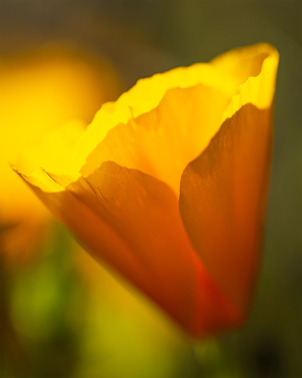
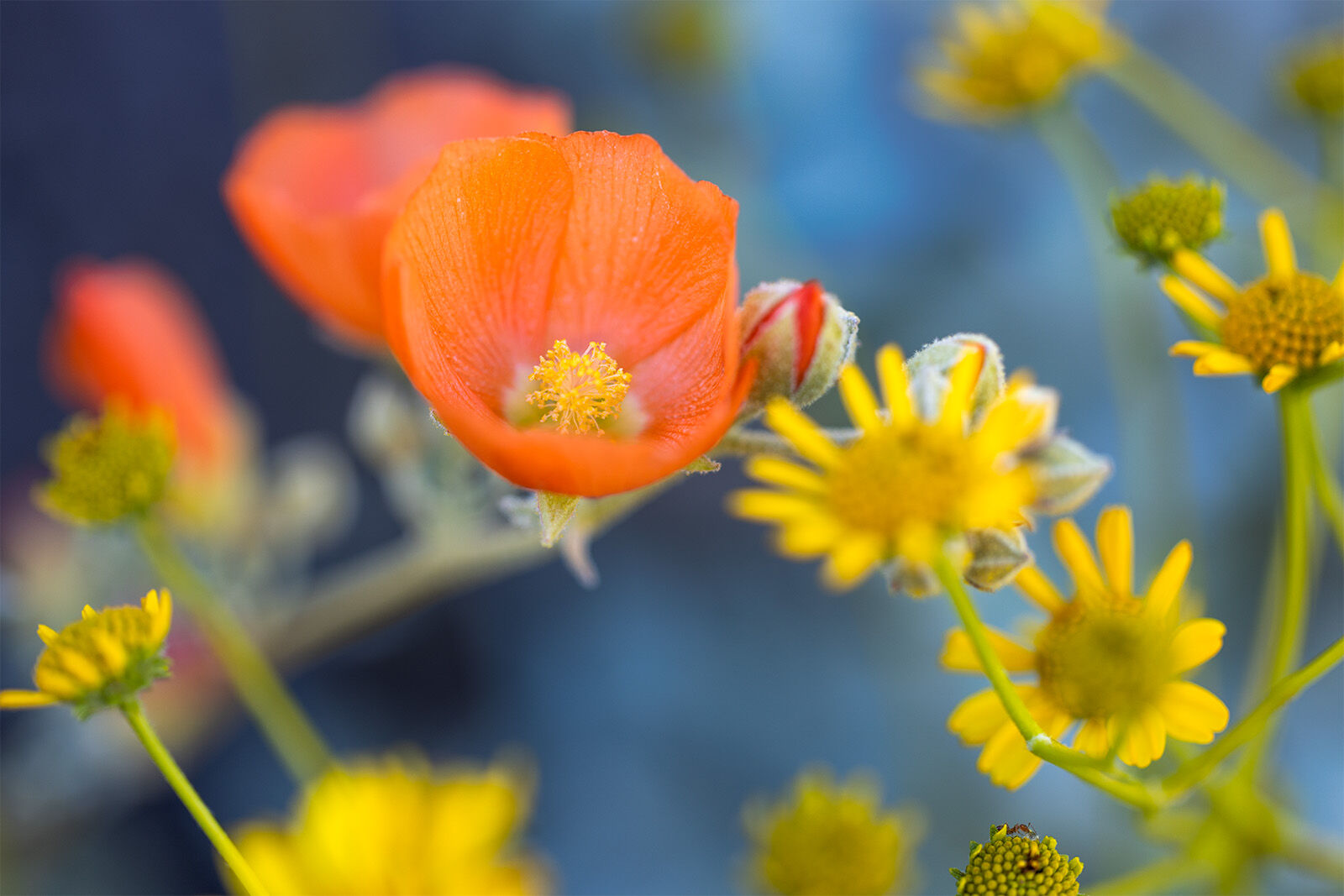
The desert southwest is generally a land of ephemeral blooms. There are always a few wildflowers that pop out of the ground around the American southwest. On occasion though, the desert gets hammered by back to back to back atmospheric rivers that dump water across much of the region. With that, the stage is set for super blooms across the southwest. We arrived around the beginning of the super bloom in Organ Pipe. Various sections of the landscape where carpeted with flowers providing some of the best conditions to photograph. If only the clouds had cooperated.
After a sunset and a sunrise in organ pipe, it was time to continue onto the eastern edge of the Sonoran Desert and explore the one national park set aside as a sanctuary of the desert, Saguaro National Park.
The eastern edge of the Sonoran desert is partially established by mountain ranges and by an increase of water. Surprisingly, the deserts of Arizona get more water than my local Colorado Plateau, but theirs comes through winter rain storms and through epic monsoons that gain their moisture coming up from Mexico and thermal convection and increased air/moisture saturation due to high air temperatures (the Colorado Plateau gets these too, but we also get snow unlike most of the Sonoran Desert). Because of these dynamics, the plants of the desert are adapted for rapid moisture uptake and slow water loss. check out moisture maps here.

Sometimes you get lucky and sometimes you are so overwhelmed by the photographic conditions it is actually hard to photograph. This image is a bit of both. I was surrounded by photographic elements, wonderful skies, and dangerous plants. I struggled to get a shot this morning, but this one I really liked.
Saguaro cactus have one large taproot that plunges into the earth with a large network of surface roots designed to absorb as much water as possible. Their accordion like skin is designed to expand and contract based on water uptake and as they get more full the thicker they get. In addition the endemic ocotillo lacks leaves all year round until a sufficient rain occurs, then it quickly sprouts leaves, blooms and goes back to dormant in order to preserve water. The ubiquitous cholla cactus pull a similar trick and photosynthesize with most of their body and modified their leaves into spines. Not as efficient as leaves, but what ever keeps you alive is the trick.
On my last day in the Sonoran desert I photographed the desert scene above. I was impressed with the cactus community within Saguaro NP west and felt overwhelmed by it as well. It was definitely a place I needed more than a day to explore. Luckily, most of the park I left un-explored so I could bring back my family one day for more fun. Unfortunately this was also the point I parted way with my traveling companions and traveled east into a new ecosystem, the Chihuahuan desert.
The Chihuahuan Desert

Unlike the other deserts I have spoken about, this desert is not characterized by a plant community but by chemistry, topography and precipitation. Though one of the major characteristics I noticed as I traveled across was the loss of major cactus groups and the increase of the yucca plant and all its variety's. In fact it was the dominate "tree" of the landscape as almost all trees vanished and the landscape faded away into very flat grasslands and creosote flats. But like great pyramids, distant mountain ranges would rise and fall from view as I travelled across this vast desert towards my second to final spot of my journey, White Sands National Park.
Though all the images I am going to show you for this educational journey are from white sands, do not take White Sands NP as the face of the Chihuahuan Desert. In fact it is an oddity being the largest gypsum sand dune field in the world according to the national park. Most of the land is as explained above, with pockets of diverse species scattered amongst it. Thousands of years ago, much of the Chihuahuan Desert was much cooler, wetter and more hospitable. In fact the earliest evidence of humans in North America come from this region, with footprints being found on an ancient lake shoreline. But as the landscape dried out, the species began to be isolated resulting in pockets of biological wonder scattered through out much of the region. The guys at white sands were proud to exclaim the 40 endemic species of moths to the region once they found out I was an ecologist.

Unfortunately, most of the Chihuahuan desert is not in New Mexico, but in Mexico. The result of that fact means I don't know much about it outside of what I have already shared. It is formed due to being in a rain shadow of two different mountain ranges, but outside of that, I don't know much.
I only got to spend and afternoon and a sunrise here at this park. I needed to continue my journey home. The afternoon was of course in a wind storm and I lacked the proper gear to deal with that. But the next morning was a wonderful experience. After packing up and enjoying my last decent breakfast on my trip I said farwell to the Chihuahuan desert and headed north west into the Colorado Plateau.
As I transitioned from the Chihuahuan Desert to the Colorado Plateau, the creosote bushes faded and the ever familiar pinyon juniper trees began to dominate the mountainsides. I had left one desert and entered my home desert. In fact, it wasn't long before I began to recognize rock layers that I usually see in and around Moab and other regions of south east Utah.
The Colorado Plateau

I was so tired when I took this image. My legs hurt, my back hurt, my shoulders hurt, my feet hurt. Pain was present but the light was sublime and I didn't walk 24 miles for nothing. So I wandered up a slop probably not walked on by a human in a hundreds of years. This is one of my favorite images I have ever taken.
The Colorado Plateau is kind of a funny desert. It has a tendency to be chopped up and placed within the Great Basin desert for a few fairly good reasons. First the plant communities are similar, though not entirely the same. It is a cold desert, similar to the Great Basin, as it snows but it actually is a drier desert than the Sonoran Desert. The Sonoran gets much more rainfall in the monsoon season than we do here in the Colorado Plateau. But unlike the other deserts I have mentioned, the Colorado Plateau is not apart of the basin and range complex. It is its own uplift with its own unique geology that in the end makes it one of the most diverse places to photograph.
My current home sits right on the edge of this desert. I look east to Zion National Park, the edge of the plateau where large faults thrust the earth up out of the ground like dragon spines from the depths of the underworld. Heading east, the plateau continues to rise until you reach Bryce canyon and Powell Point then begins to fall into the core center of the plateau. Here is where the first portion of canyon country really begins. The canyons of the Escalante to the south and the upheaval of the Capitol Reef to the north. Then comes the inner core where large sandy flats stretch across much of the center of Utah. Then the final grand carvers, the Colorado and Green Rivers cut through the stone creating the crescent shaped scar on the earth that makes up much of Moab region, Lake Powell, and the Grand Canyon. Past these, wild red sand desert regions and ancient plateaus make up some of the eastern edge of Colorado and the four corners region intercut with geological wonders like Ship Rock, Monument Valley region and Petrified Forest National Park.

Photographically I find this area to be some of the most interesting places to visit. There are uses for all lenses. The dry air means that sunsets can reach crimson colors of wonder and the landscape can be painted in crimson as the sun sets and the saturated colors begin to glow soon after the sun drops below the horizon.

An image I may never replicate ever again, with blazing light striking the cliffs in Canyonlands National Park and raging snow storms over the La Sal Mountains. Horse canyon below leads viewers back into this dramatic view.
The Colorado Plateau is home to more National Parks than any area in North America. It houses eight national parks and well over a dozen national monuments scattered between these four states. There are reasons why Guy Tal, Tom Till, and other photographers have ended up setting up shop in the canyon crags of Utah. There are few places like it in the world.
This once obscure canyon is now one of the many permitted and guided tour hikes that you can go on in Page Arizona. I was lucky enough to visit this location years before it was ever discovered by the masses.
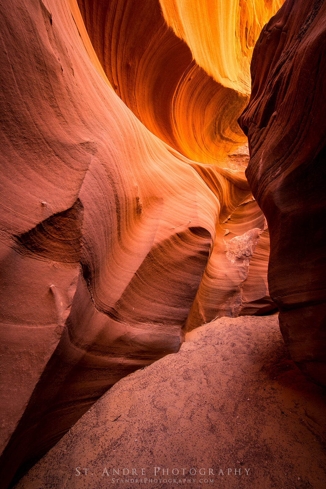
On my return trip from white sands I was able to experience the lower half of the Colorado Plateau, some of which I had never seen. The rocks though look like home and that helped orient me. As I passed from east to west the grassy flats near Petrified Forest gave way to sandstone cliffs, then eventually these too faded and I left the plateau for a bit as I hit Flagstaff, Arizona. After a quick gas refill, I turned north and headed back into the Colorado Plateau. This drive has a bit of wonder to it, particularly as you begin to head towards Page, Arizona. The cliffs rise and the road with it. To the west of Highway 89 is Marble Canyon and the Paria Plateau. To the right is the Navajo Nation and some of the most iconic slot canyons in the world.
On this particular trip I saw a massive storm sitting on top of the Paria Plateau. Turns out this was the storm that ended up killing two hikers within the Buckskin Gulch drainage. Which may be the underlying story of the deserts of the American southwest, they are anything but friendly, but at the right moments, astounding, breathtaking and beautiful.
Sometimes you get lucky and sometimes you are so overwhelmed by the photographic conditions it is actually hard to photograph. This image is a bit of both. I was surrounded by photographic elements, wonderful skies, and dangerous plants. I struggled to get a shot this morning, but this one I really liked.
